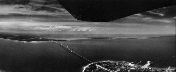
(9161) Mackinac Bridge, Aerial View, Straights of Mackinac, Michigan, 1982
Posted June 30th, 2009 by eclemens
An aerial, panoramic view of the Mackinac Bridge taken from a plane, Straights of Mackinac, Michigan. Part of series.
Photographer's notation: "The Mackinac Bridge spans the four-mile-wide Mackinac Straights, connecting Michigan's upper and lower peninsulas. The picture, which looks north, shows an area 30 miles wide and 60 miles deep. This was taken the day the world's largest suspension bridge was opened. To cut through the haze, I used film sensitive to infrared light."

Date:
5/23/1982Physdesc:
PhotographPhotographer:
Tony Spina- Login to post comments
- Thumbnail
- Printer-friendly version

 Reddit
 Facebook
 LinkedIn